StreetComplete: Fixing OpenStreetMap, one tiny quest at a time
 by ahsan
July 07, 2026
6 min read
by ahsan
July 07, 2026
6 min read
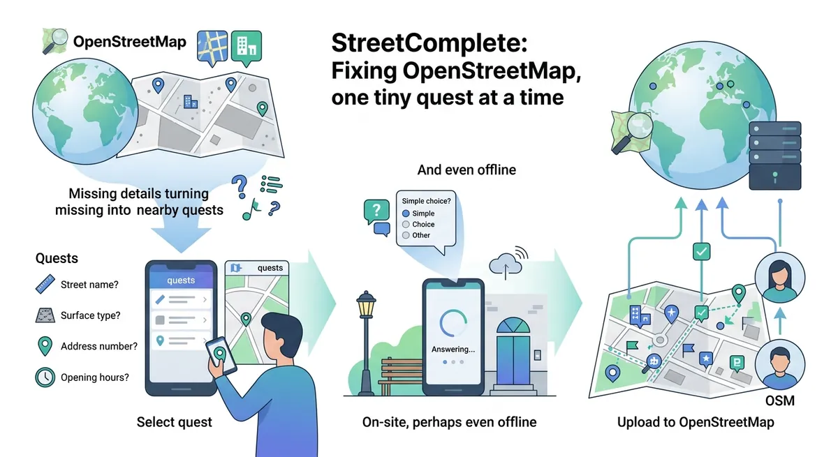
The moment you notice a “hole” in the map
Picture this: you’re walking to a café you already know exists—yet your phone’s map shows a blank spot where the entrance should be. That little mismatch feels small… until you realize it repeats everywhere: missing street names, wrong road surfaces, or no sidewalk where people clearly walk.
StreetComplete is built for exactly that moment. It’s an Android “surveyor app” for OpenStreetMap—a collaborative, crowd-edited map of the world—where the app finds missing or outdated map details nearby and turns them into bite-sized tasks called quests. You answer a simple question on location, and your answer becomes an update to the OpenStreetMap database under your OSM account. (wiki.openstreetmap.org)
How does a beginner contribute to OpenStreetMap without learning complicated tagging schemes? StreetComplete answers that question by turning editing into a guided, on-site conversation.
What “quests” really are (and why that matters)
At the heart of StreetComplete is a design choice: it avoids the typical OpenStreetMap editor workflow where you draw or reshape geometry (road lines, building polygons) and manually enter structured data.
Instead, StreetComplete shows quest pins (markers) on a map for things it believes need surveying. When you tap a pin, the app asks a straightforward question like “Is this street lit?” or “What is the road surface?” Your response is then processed and uploaded as an OpenStreetMap edit—specifically as updates to the relevant map object’s properties. (wiki.openstreetmap.org)
Two details keep the experience beginner-friendly:
- The data isn’t edited freely on-screen. StreetComplete focuses on limited edits triggered by quests, and it avoids large-scale geometry changes. (wiki.openstreetmap.org)
- Geometry is usually off-limits. In general, StreetComplete won’t let you reshape lines or areas, but it can support special cases like splitting a way when a quest property doesn’t cover the whole highlighted section. (wiki.openstreetmap.org)
This “quest-first” workflow means your brain stays in “observe + answer” mode, not “GIS + schema design” mode.
The types of things you can fix (it’s more than streetlights)
OpenStreetMap represents features (roads, buildings, amenities) using structured tags—key/value pairs like surface=gravel or lit=yes. StreetComplete’s quest catalog is essentially a curated subset of those edits that can be answered through real-world observation.
As of the app’s documented functionality, quests commonly cover areas like:
- Street lighting (whether a road is lit)
- Road surfaces and sidewalks
- Bike infrastructure (bike lanes, shared lanes, separate paths)
- Street parking
- Addresses (street names and house numbers for appropriate objects)
- “Places,” “Things,” and building types (e.g., what category a building belongs to, or what street furniture exists)
This list shows StreetComplete’s focus: capture practical details that improve day-to-day navigation. (wiki.openstreetmap.org)
For a technical learner, it’s worth noticing what’s not emphasized: route planning and navigation are not the point. StreetComplete is a field survey tool—meant to be used on foot, at the location of the feature.
The offline-first trick: download now, upload later
A surprisingly important engineering piece is offline behavior. After you download an area, the app becomes offline-capable for that area—usable even after an app restart and device restart. That matters because cellular coverage can be spotty while you’re walking around mapping. (wiki.openstreetmap.org)
When you eventually upload answers, StreetComplete can handle changes that happened in the meantime. If the relevant OpenStreetMap data moved on between “you answered” and “you uploaded,” the app uses smart automatic conflict resolution (described as improved in later versions). In database terms, this is about reconciling two edits that target the same element so the system doesn’t produce a broken state. (wiki.openstreetmap.org)
Conceptually, think of it like writing a note in a notebook today, then posting it to a shared document tomorrow—while still respecting that the document may have been updated in between.
Overlays: when beginners meet “real” editing UI
At first, StreetComplete feels like a game: tap pin, answer question, move on. But StreetComplete also supports a more advanced mode using overlays.
An overlay is a visual layer drawn on top of the base map that focuses on one aspect of OpenStreetMap data (like sidewalks or addresses). Since StreetComplete introduced overlays, advanced users can interact with those layers to edit data more directly and efficiently than pure quest pin workflows alone. (wiki.openstreetmap.org)
This also helps explain a subtle difference:
- Quest pins guide you to a single question.
- Overlays let you see and edit a category of data more broadly in a session.
For many readers, the first time overlays “click” is when you realize the app isn’t hiding OpenStreetMap complexity—it’s staging it.
Photos and privacy: the app tries to be careful
StreetComplete can collect additional evidence via photos and even GPS tracks in certain flows (especially around notes). But privacy concerns influence how that media is handled.
In the app’s FAQ documentation, there’s a noteworthy detail: by default, StreetComplete stores direction in pictures (when recorded), but it does not store GPS coordinates in those photos due to privacy concerns. It’s possible to embed GPS coordinates in JPEG files through EXIF metadata, but doing so requires special handling and post-processing. (wiki.openstreetmap.org)
EXIF, for clarity, is metadata stored inside an image file that can include camera settings and sometimes location information.
Even if you never think about this while mapping, the result is that StreetComplete’s “proof” features are designed to reduce accidental personal-location exposure.
Under the hood: what StreetComplete talks to
StreetComplete is not a separate mapping database. It connects to OpenStreetMap services to download what you need to survey and upload what you answer.
In its documented internals, the app uses the OpenStreetMap API (accessed via the Osmapi library) to download map data and upload quest results. Earlier versions used Overpass API for download, but later versions moved to the OpenStreetMap API approach. (wiki.openstreetmap.org)
One more under-the-hood update matters for anyone who cares about performance: the app’s map renderer has migrated over time. The documentation notes that version v59.0 migrated the map renderer from Tangram-ES to MapLibre. (wiki.openstreetmap.org)
So the “simple quest UI” is paired with a fairly serious systems layer that keeps maps responsive and uploads reliable.
Reality check: compatibility and current releases
StreetComplete targets Android devices with a minimum requirement of Android 7.1+. (wiki.openstreetmap.org)
On the development side, the project’s wiki lists the version at 63.1 (2026-04-24). (wiki.openstreetmap.org)
And on the release side, the GitHub releases page shows v63.2 as the latest entry, with fixes and quest/overlay improvements listed there (including map display fixes on older devices). (github.com)
Version numbers change quickly in active projects, so it’s always smart to treat those as “latest as of the published release page,” not a permanent truth.
Why this “tiny quest” strategy works
StreetComplete succeeds because it treats map quality like a logistics problem, not a wizard problem.
OpenStreetMap needs countless small corrections from real people who can observe real-world conditions. But traditional editors can intimidate newcomers because they mix UI complexity, domain knowledge (tagging rules), and careful editing. StreetComplete separates those concerns: it asks what you can answer reliably in the field, then automates the structured update behind the scenes. (wiki.openstreetmap.org)
That’s also why the app frequently revisits volatile details—like properties that can change over time (opening hours, shop status, and similar things). Periodic re-asking helps keep the map from becoming stale. (wiki.openstreetmap.org)
Conclusion: a survey app that feels like progress
StreetComplete turns OpenStreetMap editing into a walkable, understandable workflow: it finds nearby gaps, presents them as quests, and uploads your answers to OSM under your account. The app’s quest-first UI, offline-capable field usage, and careful privacy behavior make it approachable for beginners, while overlays and periodic verification give it depth for more serious contributors. (wiki.openstreetmap.org)
Comments (0)
No comments yet. Be the first to respond!
Leave a Comment
Your comment will be visible after review.